Ethiopia is yet geologically poorly studied country. It is believed that regional geological mapping started in the country during the British expedition in the late 1860s (Blanford WT, 1870). The scales of these geological maps normally range from 1:2,000,000 which cover the entire country on single sheet to 1:10,000 and larger which identify /delineate areas with mineral resources.
Coordinated geosciences mapping began in the country since the establishment of the Ethiopian Institute of Geological Surveys (EIGS) in 1968 which was first organized as a department within the Ministry of Mines and Energy. It was at this time a systematic geological mapping of the country at 1:250,000 scale began with the help of UNDP. Until 2009 regional geological, geochemical and geophysical surveys have been carried out separately by different departments of the GSE Regional Geology and Geochemistry Department; Geophysics Department, and Geochemistry Team under Economic Mineral Exploration and Evaluation Department.
However, following the BPR study conducted in the GSE in 2009 the three regional mapping programs were brought under one core process (July 2009) for integrated geosciences mapping which was later reorganized into a directorate – Basic Geoscience Mapping Directorate (BGMD).
In 2022, the Geological Survey of Ethiopia (GSE) was reorganized into the Geological Institute of Ethiopia (GIE), being served by the same supporting staff (Pull System) shared with the Ministry of Mines (MoM) and the Mineral Industry Development Institute (MIDI). Following this reorganization, the Basic Geoscience Mapping Directorate was split into independent Geoscience, Geochemistry, and Geophysics Research Desks.
In mid-2024, the GIE again gained full independence, adopting a new structure that included both core/technical and supporting staff. Under this new structure, the Geoscience and Geochemistry Research Desks were merged to form the current Geoscience Mapping and Research Directorate.
Duties and responsibilities
To conduct systematic (integrated) geological and geochemical mapping and generate quality geoscience information at various scales from regional to detail;
To identify /delineate areas with mineral resource potential based on geological and geochemical mapping data; and
To conduct follow-up studies/more detail geological and geochemical mapping of identified mineral potential areas selected for further study by the Mineral Exploration Research Directorate
Directorate Work Overview
I. Geological Mapping
Systematic geological mapping of Ethiopia at a 1:250,000 scale began in the late 1960s with support from the UNDP. However, by 2010, only 51% of the country’s territory had been mapped at this scale. This changed following the establishment of the Basic Geoscience Mapping Directorate (BGMD) in 2009, which integrated three regional mapping programs: geology, geochemistry, and geophysics.
Besides, the adoption of modern technologies in geoscience mapping, such as satellite imagery, image and data processing tools, map production software, and GPS, significantly accelerated the mapping process. These advancements allowed the generation of high-quality data and information (maps and reports) in a comparatively short time and at a reasonable cost. As a result, the 1:250,000 scale geological mapping was completed in 2017, covering the remaining 50% of the country’s land area in just seven years.
II. Geochemical Mapping
Geochemical surveys have also been carried out in the country since the establishment of the “Ethiopian Institute of Geological Surveys (EIGS). These surveys were part of almost all mineral exploration programs and projects, which were conducted at different scales either independently by the Ethiopian government or in collaboration with international organizations.
The most important geochemical surveys conducted until 1997 (see the list on the map below) cover about 20% of the country’s landmass and indeed, led to the discovery of most of the presently known metallic mineral deposits including the Lega Dembi gold and Kenticha rare metal pegmatite deposits.
NATIONAL GEOCHEMICAL MAPPING PROJECT (ETHIO-CHINESE COOPRATION PROJECT)
OBJECTIVE
The objective of the project was to generate multi-purpose geochemical data for 69 chemical elements and produce the Geochemical Atlas, as well as Metallogenic maps of the country which can be used for various purposes:
To delineate new exploration targets for mineral deposits.
As a baseline reference data for monitoring environmental changes/hazards affecting the wellbeing of the population, agricultural and urban planning activities, etc.
SCALE: 1:1,000,000
DURATION: The project duration was planned for five years: May 2016 – December 2020.
Current activities of the Directorate
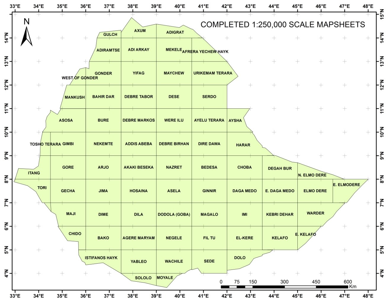
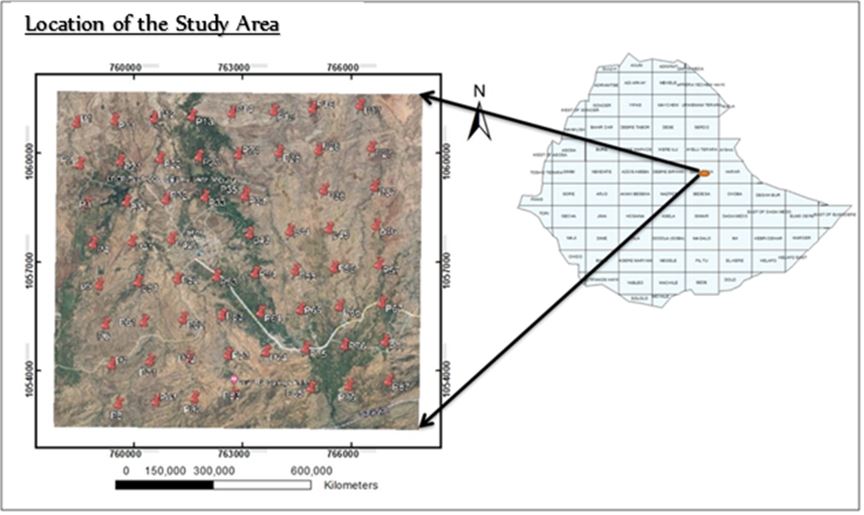
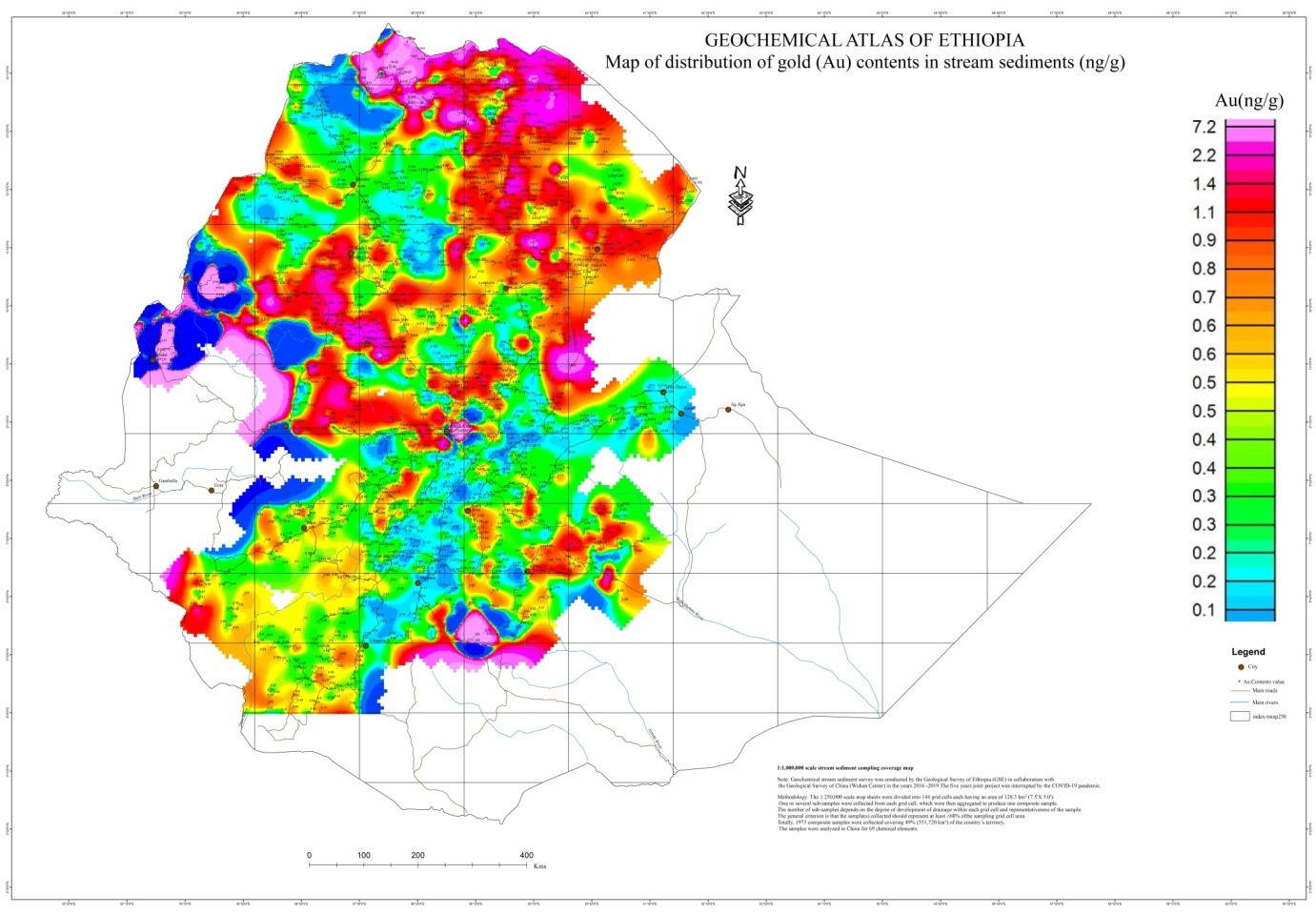
Currently the Directorate is conducting
1:50,000 scale Integrated Geological and Geochemical Mapping, and
Project: “Preparation of the Geological Map of Ethiopia at 1:500,000 scale.”